THE EGYPTIAN PYRAMIDS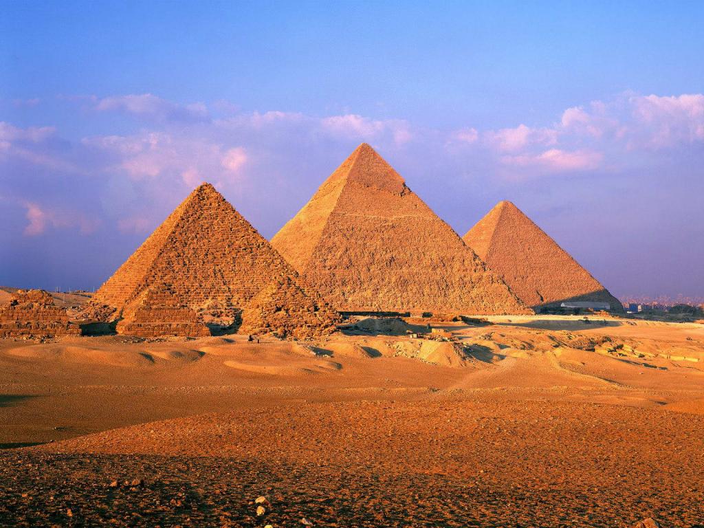
The Egyptian pyramids are ancient pyramid-shaped masonry structures located in Egypt.
There are 138 pyramids discovered in Egypt as of 2008.[1][2] Most were built as tombs for the country's Pharaohs and their consorts during the Old and Middle Kingdom periods.[3][4][5] The earliest known Egyptian pyramids are found at Saqqara, northwest of Memphis. The earliest among these is the Pyramid of Djoser (constructed 2630 BCE–2611 BCE) which was built during the third dynasty. This pyramid and its surrounding complex were designed by the architect Imhotep, and are generally considered to be the world's oldest monumental structures constructed of dressed masonry.[6] The estimate of the number of workers it took to build the pyramids have a wide range from a few thousand, twenty thousand, and up to 100,000. The most famous Egyptian pyramids are those found at Giza, on the outskirts of Cairo. Several of the Giza pyramids are counted among the largest structures ever built.[7] The Pyramid of Khufu at Giza is the largest Egyptian pyramid. It is the only one of the Seven Wonders of the Ancient World still in existence. |
THE AMERICAN STATUE OF LIBERTY

The Statue of Liberty National Monument officially celebrated her 100th birthday on October 28, 1986. The people of France gave the Statue to the people of the United States over one hundred years ago in recognition of the friendship established during the American Revolution. Over the years, the Statue of Liberty's symbolism has grown to include freedom and democracy as well as this international friendship. Sculptor Frederic Auguste Bartholdi was commissioned to design a sculpture with the year 1876 in mind for completion, to commemorate the centennial of the American Declaration of Independence. The Statue was a joint effort between America and France and it was agreed upon that the American people were to build the pedestal, and the French people were responsible for the Statue and its assembly here in the United States. However, lack of funds was a problem on both sides of the Atlantic Ocean. In France, public fees, various forms of entertainment, and a lottery were among the methods used to raise funds. In the United States, benefit theatrical events, art exhibitions, auctions and prize fights assisted in providing needed funds.
Meanwhile in France, Bartholdi required the assistance of an engineer to address structural issues associated with designing such a colossal copper sculpture. Alexandre Gustave Eiffel (designer of the Eiffel Tower) was commissioned to design the massive iron pylon and secondary skeletal framework which allows the Statue's copper skin to move independently yet stand upright. Back in America, fund raising for the pedestal was going particularly slowly, so Joseph Pulitzer (noted for the Pulitzer Prize) opened up the editorial pages of his newspaper, "The World" to support the fund raising effort. Pulitzer used his newspaper to criticize both the rich who had failed to finance the pedestal construction and the middle class who were content to rely upon the wealthy to provide the funds. Pulitzer's campaign of harsh criticism was successful in motivating the people of America to donate. Financing for the pedestal was completed in August 1885, and pedestal construction was finished in April of 1886. The Statue was completed in France in July, 1884 and arrived in New York Harbor in June of 1885 on board the French frigate "Isere" which transported the Statue of Liberty from France to the United States. In transit, the Statue was reduced to 350 individual pieces and packed in 214 crates. The Statue was re-assembled on her new pedestal in four months time. On October 28th 1886, the dedication of the Statue of Liberty took place in front of thousands of spectators. She was a centennial gift ten years late. The story of the Statue of Liberty and her island has been one of change. The Statue was placed upon a granite pedestal inside the courtyard of the star-shaped walls of Fort Wood (which had been completed for the War of 1812.) The United States Lighthouse Board had responsibility for the operation of the Statue of Liberty until 1901. After 1901, the care and operation of the Statue was placed under the War Department. A Presidential Proclamation declared Fort Wood (and the Statue of Liberty within it) a National Monument on October 15th, 1924 and the monument's boundary was set at the outer edge of Fort Wood. In 1933, the care and administration of the National Monument was transferred to the National Park Service. On September 7, 1937, jurisdiction was enlarged to encompass all of Bedloe's Island and in 1956, the island's name was changed to Liberty Island. On May 11, 1965, Ellis Island was also transferred to the National Park Service and became part of the Statue of Liberty National Monument. In May of 1982, President Ronald Reagan appointed Lee Iacocca to head up a private sector effort to restore the Statue of Liberty. Fundraising began for the $87 million restoration under a public/private partnership between the National Park Service and The Statue of Liberty-Ellis Island Foundation, Inc., to date the most successful public-private partnership in American history. In 1984, at the start of the Statue's restoration, the United Nations designated the Statue of Liberty as a World Heritage Site. On July 5, 1986 the newly restored Statue re-opened to the public during Liberty Weekend, which celebrated her centennial |
COLLOSSEUM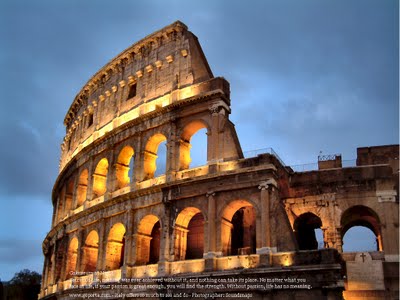
The Colosseum, or the Coliseum, originally the Flavian Amphitheatre (Latin: Amphitheatrum Flavium, Italian Anfiteatro Flavio or Colosseo), is an elliptical amphitheatre in the centre of the city of Rome, Italy, the largest ever built in the Roman Empire. It is considered one of the greatest works of Roman architecture and Roman engineering.
Occupying a site just east of the Roman Forum, its construction started in 72 AD[1] under the emperor Vespasian and was completed in 80 AD under Titus,[2] with further modifications being made during Domitian's reign (81–96).[3] The name "Amphitheatrum Flavium" derives from both Vespasian's and Titus's family name (Flavius, from the gens Flavia). Capable of seating 50,000 spectators,[4][5] the Colosseum was used for gladiatorial contests and public spectacles such as mock sea battles, animal hunts, executions, re-enactments of famous battles, and dramas based on Classical mythology. The building ceased to be used for entertainment in the early medieval era. It was later reused for such purposes as housing, workshops, quarters for a religious order, a fortress, a quarry, and a Christian shrine. Although in the 21st century it stays partially ruined because of damage caused by devastating earthquakes and stone-robbers, the Colosseum is an iconic symbol of Imperial Rome. It is one of Rome's most popular tourist attractions and still has close connections with the Roman Catholic Church, as each Good Friday the Pope leads a torchlit "Way of the Cross" procession that starts in the area around the Colosseum.[6] The Colosseum is also depicted on the Italian version of the five-cent euro coin. Construction of the Colosseum began under the rule of the Emperor Vespasian[3] in around 70–72 AD. The site chosen was a flat area on the floor of a low valley between the Caelian, Esquiline and Palatine Hills, through which a canalised stream ran. By the 2nd century BC the area was densely inhabited. It was devastated by the Great Fire of Rome in AD 64, following which Nero seized much of the area to add to his personal domain. He built the grandiose Domus Aurea on the site, in front of which he created an artificial lake surrounded by pavilions, gardens and porticoes. The existing Aqua Claudia aqueduct was extended to supply water to the area and the gigantic bronze Colossus of Nero was set up nearby at the entrance to the Domus Aurea.[12] Although the Colossus was preserved, much of the Domus Aurea was torn down. The lake was filled in and the land reused as the location for the new Flavian Amphitheatre. Gladiatorial schools and other support buildings were constructed nearby within the former grounds of the Domus Aurea. According to a reconstructed inscription found on the site, "the emperor Vespasian ordered this new amphitheatre to be erected from his general's share of the booty." This is thought to refer to the vast quantity of treasure seized by the Romans following their victory in the Great Jewish Revolt in 70 AD. The Colosseum can be thus interpreted as a great triumphal monument built in the Roman tradition of celebrating great victories,[12] placating the Roman people instead of returning soldiers. Vespasian's decision to build the Colosseum on the site of Nero's lake can also be seen as a populist gesture of returning to the people an area of the city which Nero had appropriated for his own use. In contrast to many other amphitheatres, which were located on the outskirts of a city, the Colosseum was constructed in the city centre; in effect, placing it both literally and symbolically at the heart of Rome. The Colosseum had been completed up to the third story by the time of Vespasian's death in 79. The top level was finished and the building inaugurated by his son, Titus, in 80.[3] Dio Cassius recounts that over 9,000 wild animals were killed during the inaugural games of the amphitheatre. The building was remodelled further under Vespasian's younger son, the newly designated Emperor Domitian, who constructed the hypogeum, a series of underground tunnels used to house animals and slaves. He also added a gallery to the top of the Colosseum to increase its seating capacity. In 217, the Colosseum was badly damaged by a major fire (caused by lightning, according to Dio Cassius[13]) which destroyed the wooden upper levels of the amphitheatre's interior. It was not fully repaired until about 240 and underwent further repairs in 250 or 252 and again in 320. An inscription records the restoration of various parts of the Colosseum under Theodosius II and Valentinian III (reigned 425–455), possibly to repair damage caused by a major earthquake in 443; more work followed in 484[14] and 508. The arena continued to be used for contests well into the 6th century, with gladiatorial fights last mentioned around 435. Animal hunts continued until at least 523, when Anicius Maximus celebrated his consulship with some venationes, criticised by King Theodoric the Great for their high cost.[12] |
GREAT WALL OF CHINA
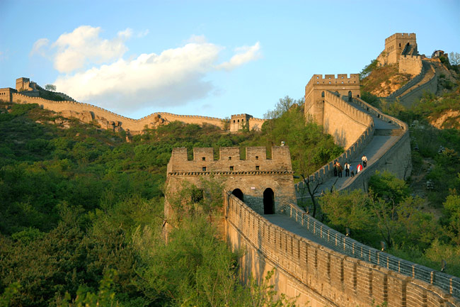
The Great Wall of China is a series of fortifications made of stone, brick, tamped earth, wood, and other materials, generally built along an east-to-west line across the historical northern borders of China in part to protect the Chinese Empire or its prototypical states against intrusions by various nomadic groups or military incursions by various warlike peoples or forces. Several walls were being built as early as the 7th century BC;[3] these, later joined together and made bigger, stronger, and unified are now collectively referred to as the Great Wall.[4] Especially famous is the wall built between 220–206 BC by the first Emperor of China, Qin Shi Huang. Little of that wall remains. Since then, the Great Wall has on and off been rebuilt, maintained, enhanced; the majority of the existing wall was reconstructed during the Ming Dynasty.
Other purposes of the Great Wall have included border controls, allowing the imposition of duties on goods transported along the Silk Road, regulation or encouragement of trade and the control of immigration and emigration. Furthermore, the defensive characteristics of the Great Wall were enhanced by the construction of watch towers, troop barracks, garrison stations, signaling capabilities through the means of smoke or fire, and the fact that the path of the Great Wall also served as a transportation corridor. The Great Wall stretches from Shanhaiguan in the east, to Lop Lake in the west, along an arc that roughly delineates the southern edge of Inner Mongolia. A comprehensive archaeological survey, using advanced technologies, has concluded that the Ming walls measure 8,850 km (5,500 mi).[5] This is made up of 6,259 km (3,889 mi) sections of actual wall, 359 km (223 mi) of trenches and 2,232 km (1,387 mi) of natural defensive barriers such as hills and rivers.[5] Another archaeological survey found that the entire wall with all of its branches measure out to be 21,196 km (13,171 mi).[6] The Chinese were already familiar with the techniques of wall-building by the time of the Spring and Autumn Period between the 8th and 5th centuries BCE[7] During this time and the subsequent Warring States Period, the states of Qin, Wei, Zhao, Qi, Yan and Zhongshan[8][9] all constructed extensive fortifications to defend their own borders. Built to withstand the attack of small arms such as swords and spears, these walls were made mostly by stamping earth and gravel between board frames. Qin Shi Huang conquered all opposing states and unified China in 221 BCE, establishing the Qin Dynasty. Intending to impose centralized rule and prevent the resurgence of feudal lords, he ordered the destruction of the wall sections that divided his empire along the former state borders. To protect the empire against intrusions by the Xiongnu people from the north, he ordered the building of a new wall to connect the remaining fortifications along the empire's new northern frontier. Transporting the large quantity of materials required for construction was difficult, so builders always tried to use local resources. Stones from the mountains were used over mountain ranges, while rammed earth was used for construction in the plains. There are no surviving historical records indicating the exact length and course of the Qin Dynasty walls. Most of the ancient walls have eroded away over the centuries, and very few sections remain today. The human cost of the construction is unknown, but it has been estimated by some authors that hundreds of thousands,[10] if not up to a million, workers died building the Qin wall.[11][12] Later, the Han,[13] Sui, and Northern dynasties all repaired, rebuilt, or expanded sections of the Great Wall at great cost to defend themselves against northern invaders.[14] The Tang and Song Dynasties did not build any walls in the region.[14] The Liao, Jin, and Yuan dynasties, who ruled Northern China throughout most of the 10-13th centuries, had their original power bases north of the Great Wall proper. Accordingly, they would have no need throughout most of their history to build a wall along this line. The Liao carried out limited repair of the Great Wall in a few areas,[15] however the Jin did construct defensive walls in the 12th century, but those were located much to the north of the Great Wall as we know it, within today's Inner and Outer Mongolia.[14][16] |
CRISTO-REI
The Christ the King statue (Portuguese: Cristo-Rei) is a Catholic monument and shrine dedicated to the Sacred Heart of Jesus Christ overlooking the city of Lisbon in the central part of Portugal. It was inspired by the Christ the Redeemer statue in Rio de Janeiro (Brazil), after the Cardinal Patriarch of Lisbon visited that monument. The project was inaugurated on 17 May 1959, at a time when Portugal was being ruled by the authoritarian President of the Council of Ministers António de Oliveira Salazar (permission to build the monument was ultimately decided by this ruler). The giant statue in cement was erected to symbolize the gratitude the Portuguese were spared the effects of World War II
The construction of Cristo-Rei was approved on a Portuguese Episcopate conference, held in Fátima on 20 April 1940, as a plea to God to release Portugal from entering World War II.[1] However, the idea had originated on a visit by the Cardinal Patriarch of Lisbon to Rio de Janeiro in 1934, soon after the inauguration of the statue of Christ the Redeemer in 1931.[1][2] In 1941 the land that would eventually be used to construct the monument was acquired. ref name=CRHistoria/> It was only in 1949, when the cornerstone was finally placed on the site, and managed by the Portuguese Episcopate.[1][2] Construction started in 1949 and took ten years to complete, funded and supported by Apostleship of Prayer members.[1] Yet, it would only be in 1952 that the first construction would occur on the site: at that time the foundations of the monument were established by Empresa de Construções OPCA (at the time, at a cost of 3.020 contos).[2] The inauguration of the many structure officially began on 17 May 1959, and continued during the middle of the 20th century. It was in 1984, the 25th anniversary of the Shrine, that the Chapel of Nossa Senhora da Paz was first inaugurated.[1][2] In addition, a general plan was approved to recondition the grounds of the Shrine, under the direction of Luiz Cunha and Domingos Ávila Gomes, which included the construction of the Sanctuary building, that included rectory, administration, chapel, meeting rooms and exhibition galleries.[2] ref name=CRHistoria/> When, on 16 July 1975, Pope Paul VI created the Diocese of Setúbal under the Papal bull Studentes Nos the Monument to Christ the King and the Seminary of Almada stayed under the control of the Patriarchate of Lisbon.[1] In June 1999 the site came under the authority of the Diocese of Setúbal, which immediately worked to restore the monument.[1] The municipal authority was responsible for public works beginning in May 2001 to clean the area and reorganize the public spaces, under the technical supervision of the School of Sciences and Technology of the Universidade Nova de Lisboa.[2] Following these restorations and maintenance projects, the monument was reopened in a solemn ceremony occurring on 1 February 2001. Owing to its national importance the Conference of Bishops determined that funds collected throughout the country on 23 November 2003 would be used to pay for the restoration. In order to support pilgrimages to the site, in June 2004 new spaces in the Sanctuary building were inaugurated, that included a dining room with capacity for 150 people and two segregated dormitories.[1][2] This was followed on 17 May 2005, with the inauguration of a 150-person dining area and 80-person meeting hall, in addition to two segregated dormitories, dining room and kitchen.[1] Improvements to the monument of Christ the King began in 2006.[2] By 17 May of that year, the Chapel of Our Lady of Peace was inaugurated, under the collaboration of architect João de Sousa Araújo.[1] At about the same time, in the following year (17 May 2007), the Pope John XXIII hall was opened, containing eight oil paintings by the same architect, including images from the enclyclical Pax in Terris and statue of the Angel of Portugal.[1] Similarly, the old high cross from the Shrine of Fátima was donated to Sanctuary, and unveiled on the same day.[1] On 25 November 2005, the newly remodeled main sacristy in the monument's chapel, that featured the original statue of the monument by sculptor Francisco Franco, was reopened.[1] On 17 May 2008, the Chapel of the Confidants of the Heart of Jesus, containing valuable reliquaries was inaugurated, along with the Ten Commandments in bronze, which were placed on the main face of the Monument.[1] The inauguration of the Chapel of the Blessed Sacrament (6 January 2009) witnessed the apresentation of two paintings related to the revelations made Saint Margaret Mary Alacoque and another, which was placed above the tabernacle.[1] Pope Benedict XVI over flew the shrine in his apostolic visit to Portugal in May 2010. |
Taj Mahal
|
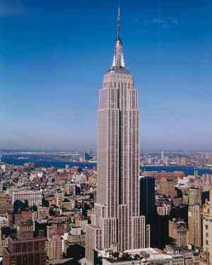
Empire State Building
|
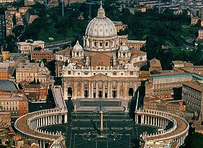
St. Peter’s Basilica
|
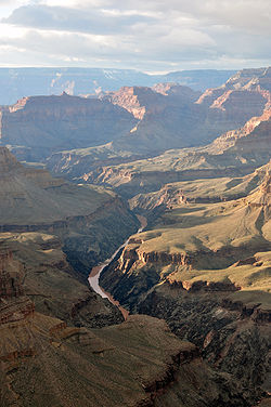
Grand Canyon
|
HIGH DAM
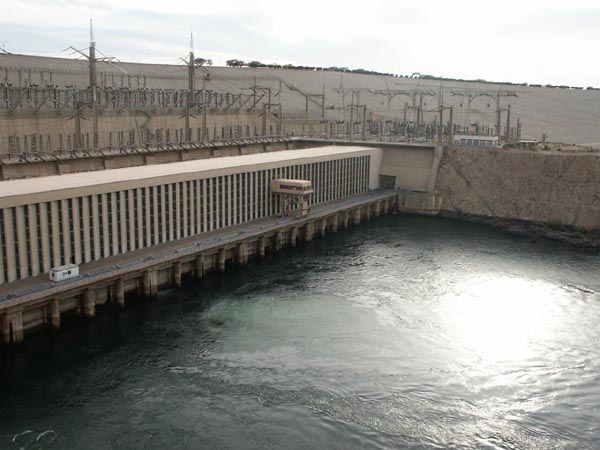
The Aswan Dam is an embankment dam situated across the Nile River in Aswan, Egypt. Since the 1950s, the name commonly refers to the High Dam. Construction of the High Dam became a key objective of the Egyptian Government following the Egyptian Revolution of 1952, as the ability to control floods, provide water for irrigation, and generate hydroelectricity were seen as pivotal to Egypt's industrialisation. The High Dam was constructed between 1960 and 1970, and has had a significant impact on the economy and culture of Egypt.
Before the dams were built, the Nile River flooded every year during late summer, when water flowed down the valley from its East African drainage basin. These floods brought high water and natural nutrients and minerals that annually enriched the fertile soil along the floodplain and delta; this had made the Nile valley ideal for farming since ancient times. Because floods vary, in high-water years the whole crop might be wiped out, while in low-water years widespread drought and famine occasionally occurred. As Egypt's population grew and conditions changed, both a desire and ability developed to control the floods, and thus both protect and support farmland and the economically important cotton crop. With the reservoir storage provided by the Aswan dams, the floods could be lessened and the water stored for later release. The earliest recorded attempt to build a dam near Aswan was in the 11th century, when the Arab polymath and engineer Ibn al-Haytham (known as Alhazen in the West) was summoned to Egypt by the Fatimid Caliph, Al-Hakim bi-Amr Allah, to regulate the flooding of the Nile, a task requiring an early attempt at an Aswan Dam.[1] His field work convinced him of the impracticality of this scheme,[2] The British began construction of the first dam across the Nile in 1898. Construction lasted until 1902, and the dam was opened on 10 December 1902. The project was designed by Sir William Willcocks and involved several eminent engineers, including Sir Benjamin Baker and Sir John Aird, whose firm, John Aird & Co., was the main contractor After the Low Dam was almost over-topped in 1946, the British administration decided that rather than raise the dam a third time, a second dam should be built some 7 km upriver. The post-war years saw major changes in Egypt, including the growth of nationalism, the abrogation of the Anglo-Egyptian Treaty of 1936, and the overthrow of the monarchy, led by the Free Officers Movement, including its ultimate leader, Gamal Abdel Nasser, as well as Anwar Sadat. Planning for the "High Dam" proper began in 1954, following the revolution, and changed development priorities. Initially, both the US and USSR were interested in the development of the dam, but this occurred in the increasingly tense readings of Cold War happenings, as well as growing intra-Arab rivalries. In 1955 Nasser was trying to portray himself as the leader of Arab nationalism, in opposition to the traditional monarchies, especially Hashemite Iraq following its signing of the 1955 Baghdad Pact. At that time the US feared that communism would spread to the Middle East and saw Nasser as a natural leader of an anti-communist Arab league. The US and Britain offered to help finance construction of the high dam, with a loan of US$270 million, in return for Nasser's leadership in resolving the Arab-Israeli conflict. While opposed both to communism and imperialism, Nasser presented himself as a tactical neutralist, and sought to work with both the US and USSR for Egyptian and Arab benefit.[5] After a particularly criticized raid by Israel against Egyptian forces in Gaza in 1955, Nasser realized that he could not legitimately portray himself as the leader of pan-Arab nationalism if he could not defend his country militarily against Israel. In addition to his development plans, he looked to quickly modernize his military, and turned first to the US. US Secretary of State John Foster Dulles and US President Dwight Eisenhower told Nasser that the US would supply him with weapons only if they were used for defensive purposes and accompanied by US military personnel for supervision and training. Nasser did not accept these conditions and then looked to the Soviet Union for support. Although Dulles believed that Nasser was only bluffing and that the USSR would not aid Nasser, he was wrong; the USSR promised Nasser a quantity of arms in exchange for a deferred payment of Egyptian grain and cotton. On 27 September 1955, Nasser announced an arms deal, with Czechoslovakia acting as a middleman for the Soviet support.[6] Instead of retaliating against Nasser for turning to the Soviets, Dulles sought to improve relations with him. This explains the later offer of December 1955, in which the US and UK pledged $56 and $14 million respectively towards the construction of the dam.[7] Though the "Czech arms deal" actually increased US willingness to invest in Aswan, the British cited the deal as a reason for withdrawing their funding. What angered Dulles much more was Nasser’s recognition of communist China, which was in direct conflict with Dulles's policy of containment.[8] There are several other reasons why the US decided to withdraw the offer of funding. Dulles believed that the Soviet Union would not fulfill its commitment to help the Egyptians. He was also irritated by Nasser’s neutrality and attempts to play both sides of the Cold War. At the time, other western allies in the Middle East, including Turkey and Iraq, were irritated that Egypt, a persistently neutral country, was being offered so much aid.[9] In June 1956 the Soviets offered Nasser $1,120,000,000 at 2% interest for the construction of the dam. On 19 July the US State Department announced that American financial assistance for the High Dam was "not feasible in present circumstances."[7] On 26 July 1956, with wide Egyptian acclaim, Nasser announced the nationalization of the Suez Canal as well as fair compensation for the former owners. Nasser planned on the revenues generated by the canal helping to fund construction of the High Dam. When the Suez War broke out, the United Kingdom, France, and Israel were mainly successful in attaining their immediate military objectives, but pressure from the US and the USSR at the United Nations and elsewhere forced them to withdraw. In 1958 the Soviet Union provided funding for the dam project. |
burj khalifa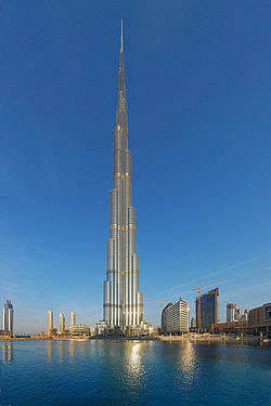
Burj Khalifa (Arabic: برج خليفة "Khalifa Tower"),[8] known as Burj Dubai prior to its inauguration, is a skyscraper in Dubai, United Arab Emirates, and is the tallest manmade structure in the world, at 829.84 m (2,723 ft).[3][8] Construction began on 21 September 2004, with the exterior of the structure completed on 1 October 2009. The building officially opened on 4 January 2010,[1][9] and is part of the new 2 km2 (490-acre) flagship development called Downtown Dubai at the 'First Interchange' along Sheikh Zayed Road, near Dubai's main business district. The tower's architecture and engineering were performed by Skidmore, Owings and Merrill of Chicago, with Adrian Smith as chief architect, and Bill Baker as chief structural engineer.[10][11] The primary contractor was Samsung C&T of South Korea.[12]
The total cost for the project was about US$1.5 billion; and for the entire "Downtown Dubai" development, US$20 billion.[13] In March 2009, Mohamed Ali Alabbar, chairman of the project's developer, Emaar Properties, said office space pricing at Burj Khalifa reached US$4,000 per sq ft (over US$43,000 per m²) and the Armani Residences, also in Burj Khalifa, sold for US$3,500 per sq ft (over US$37,500 per m²).[14] The project's completion coincided with the global financial crisis of 2007–2012, and with vast overbuilding in the country, this led to high vacancies and foreclosures.[15] With Dubai mired in debt from its huge ambitions, the government was forced to seek multibillion dollar bailouts from its oil-rich neighbor Abu Dhabi. Subsequently, in a surprise move at its opening ceremony, the tower was renamed Burj Khalifa, said to honour the UAE President Khalifa bin Zayed Al Nahyan for his crucial support.[16] Due to the slumping demand in Dubai's property market, the rents in the Burj Khalifa plummeted 40% some ten months after its opening. Out of 900 apartments in the tower, around 825 were still empty at that time.[17][18] Burj Khalifa was designed to be the centerpiece of a large-scale, mixed-use development that would include 30,000 homes, nine hotels (including The Address Downtown Dubai), 3 hectares (7.4 acres) of parkland, at least 19 residential towers, the Dubai Mall, and the 12-hectare (30-acre) man-made Burj Khalifa Lake. The building has returned the location of Earth's tallest freestanding structure to the Middle East where the Great Pyramid of Giza claimed this achievement for almost four millennia before being surpassed in 1311 by Lincoln Cathedral in England. The decision to build Burj Khalifa is reportedly based on the government's decision to diversify from an oil based economy to one that is service and tourism based. According to officials, it is necessary for projects like Burj Khalifa to be built in the city to garner more international recognition, and hence investment. "He (Sheikh Mohammed bin Rashid Al Maktoum) wanted to put Dubai on the map with something really sensational," said Jacqui Josephson, a tourism and VIP delegations executive at Nakheel Properties.[19] |
burj el arab
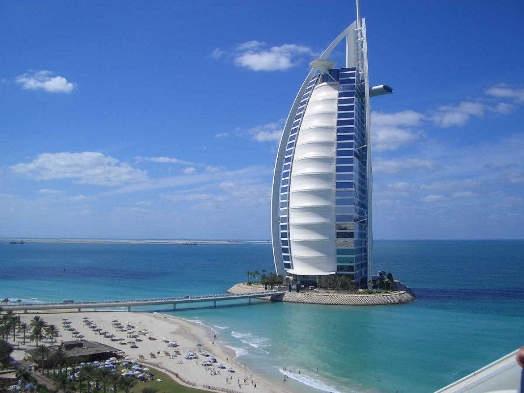
Burj Al Arab (Arabic: برج العرب,Tower of the Arabs) is a luxury hotel located in Dubai, United Arab Emirates. At 321 m (1,053 ft), it is the fourth tallest hotel in the world. Burj Al Arab stands on an artificial island 280 m (920 ft) out from Jumeirah beach, and is connected to the mainland by a private curving bridge. The shape of the structure is designed to mimic the sail of a ship. Sometimes incorrectly referred to as "the world's only seven-Star hotel", its star rating has been often debated.
The beachfront area where Burj Al Arab and Jumeirah Beach Hotel are located was previously called Chicago Beach.[7] The hotel is located on an island of reclaimed land 280 meters offshore of the beach of the former Chicago Beach Hotel.[8] The locale's name had its origins in the Chicago Bridge & Iron Company which at one time welded giant floating oil storage tankers on the site.[7] The old name persisted after the old Hotel was demolished in 1997. Dubai Chicago Beach Hotel remained as the Public Project Name for the construction phase of Burj Al Arab Hotel until Sheikh Mohammed bin Rashid Al Maktoum announced the new name Burj Al Arab was designed by architect Tom Wright of WS Atkins PLC. The design and construction were managed by Canadian engineer Rick Gregory also of WS Atkins. Construction of the Island began in 1994. It was built to resemble the sail of a dhow, a type of Arabian vessel. Two "wings" spread in a V to form a vast "mast", while the space between them is enclosed in a massive atrium. The architect Tom Wright[10] said "The client wanted a building that would become an iconic or symbolic statement for Dubai; this is very similar to Sydney with its Opera House, London with Big Ben, or Paris with the Eiffel Tower. It needed to be a building that would become synonymous with the name of the country."[11] The architect and engineering consultant for the project was Atkins. Fletcher Construction from New Zealand was the lead joint venture partner in the initial stages of pre-construction and construction.[12] The hotel was built by South African construction contractor Murray & Roberts and Al Habtoor Engineering.[13] The building opened in December 1999. Several features of the hotel required complex engineering feats to achieve. The hotel rests on an artificial island constructed 280 m (920 ft) offshore. To secure a foundation, the builders drove 230 forty-meter (130 ft) long concrete piles into the sand.[14] Engineers created a ground/surface layer of large rocks, which is circled with a concrete honeycomb pattern, which serves to protect the foundation from erosion. It took three years to reclaim the land from the sea, while it took fewer than three years to construct the building itself. The building contains over 70,000 m3 (92,000 cu yd) of concrete and 9,000 tons of steel.[14] Inside the building, the atrium is 180 m (590 ft) tall. Burj Al Arab is the world's fourth tallest hotel (not including buildings with mixed use). The structure of the Rose Rayhaan, also in Dubai, is 11 m (36 ft) taller than Burj Al Arab. |
cairo tower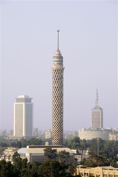
The Cairo Tower (Arabic: برج القاهرة, Borg Al-Qāhira) is a free-standing concrete tower located in Cairo, Egypt. At 187 m (614 ft), it has been the tallest structure in Egypt and North Africa for 50 years. It was the tallest structure in Africa for 10 years, until 1971 when it was surpassed by Hillbrow Tower in South Africa.
One of Cairo's well-known landmarks, it stands in the Zamalek district on Gezira Island in the River Nile, close to Downtown Cairo Built from 1956 to 1961,[clarification needed] the tower was designed by the Egyptian architect Naoum Chebib. Its partially open lattice-work design is intended to evoke a pharaonic lotus plant, an iconic symbol of Ancient Egypt. The tower is crowned by a circular observation deck and a rotating restaurant with a view over greater Cairo. One rotation takes approximately 70 minutes. In the 1960s, Egyptian President Gamal Abdel Nasser announced that the funds for the construction of the Tower originated with the Government of the United States, which had provided $100,000 to him as a personal gift with the intent of currying his favour. Affronted by the attempt to bribe him, Nasser decided to publicly rebuke the U.S. government by transferring the entirety of the funds to the Egyptian government for use in building the Tower. Between November 2004 and 17 May 2009 it underwent a EGP 35 million restoration project, completed in time for its fiftieth anniversary on April |
eiffel tower
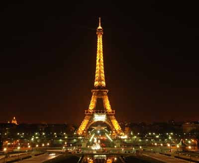
The Eiffel Tower (French: La Tour Eiffel, [tuʁ ɛfɛl], nickname La dame de fer, the iron lady) is a puddled iron[10] lattice tower located on the Champ de Mars in Paris. Built in 1889 as the entrance arch to the 1889 World's Fair, it has become both a global cultural icon of France and one of the most recognizable structures in the world. The tower is the tallest building in Paris[11] and the most-visited paid monument in the world; millions of people ascend it every year. It is named after the engineer Gustave Eiffel, whose company designed and built the tower.
The tower stands 320 metres (1,050 ft) tall, about the same height as an 81-story building. During its construction, the Eiffel Tower surpassed the Washington Monument to assume the title of the tallest man-made structure in the world, a title it held for 41 years, until the Chrysler Building in New York City was built in 1930. However, because of the addition, in 1957, of the antenna atop the Eiffel Tower, it is now taller than the Chrysler Building. Not including broadcast antennas, it is the second-tallest structure in France, after the Millau Viaduct. The tower has three levels for visitors. Tickets can be purchased to ascend, by stairs or lift (elevator), to the first and second levels. The walk from ground level to the first level is over 300 steps, as is the walk from the first to the second level. The third and highest level is accessible only by lift - stairs exist but they are not usually open for public use. Both the first and second levels feature restaurants. The tower has become the most prominent symbol of both Paris and France, often in the establishing shot of films set in the city. |
